
France VFR presenteert Basse Normandie
De nieuwe VFR Regional-serie van France VFR is ontworpen en ontwikkeld om een omgeving te bieden die zo realistisch mogelijk is voor het maken van VFR-vluchten boven het mooie Frankrijk. Het is de optelsom van jarenlange ervaring met vluchtsimulatie en met 3D-modellering.
De “VFR Regional” -producten bevatten alle de nieuwe 3DAutomation®-technologie, die in eigen beheer is ontwikkeld door France VFR. Deze technologie maakt het mogelijk om zeer realistische omgevingen te genereren. Het is niet de bedoeling om de echte wereld nauwkeurig te modelleren, maar om een “as real as it gets” ervaring te scheppen.
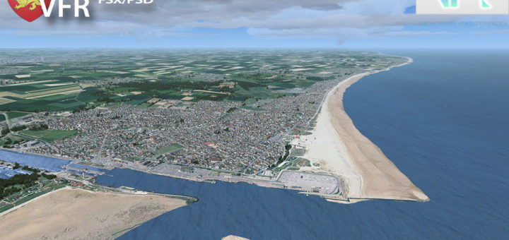
Basse Normandie ligt tussen de gebieden Haute Normandie en Bretagne in en de grootste luchthavens zijn Cherbourg (LFRC), Deauville (LFRG) en Caen (LFRK).
Een video van deze regio kunt u hier zien. VFR Regional is geschikt voor FSX, FSX SE en voor Prepar3D tot en met v3. De scenery is te koop op fspilotshop en kost ongeveer €42.
Technical Specifications
- Ground textures from 0.85 to 1 meter / pixel resolution from IGN aerial photography reworked for an optimal visual rendition in Flight Simulator X (summer only)
- Dedicated mesh with high definition 4.75 meters (LOD13)
- Lakes and rivers with navigable waters fitting the texture
- Transparency management of the seabed on the entire scene
- Semi-detailed airports including flatten platform correction
- Obstacles and VFR landmarks modeled on the entire scene including the official SIA database (antennas, towers, water towers, wind turbines, various constructions …)
- Hundreds of thousands of objects and notable buildings integrated into the environment (churches, power plants, silos, castles, industrial tanks, bridges, tolls, cranes, boats, streetlights, road signs …)
- Integration of 3D Automation® technology allowing multi-million buildings and realistic vegetation areas fitting geographic specs
- Extremely dense and optimized vegetation coverage using a custom rendering module controlled by artificial intelligence (AI)
- Autogen buildings including additional specific and optimized 3D variations
- Geo-referenced data for maximum compatibility with future add-ons installed on the same area
- Development process 100% Microsoft SDK specifications compliant, ensuring maximum compatibility with new releases


Dank
Hoi het CTD probleem met Sim Update 3 Bèta is inmiddels opgelost, zie mijn laatste artikel :-) https://www.fsvisions.nl/ctd-probleem-msfs2024-su3-beta-opgelost/
Of juist Roblox v100?
Hoi WielXP, Dank voor de tip, ga het zeker eens proberen! Fijn weekend! M.v.g. Matthias
Naast dit nieuwe vliegtuig met de carrier is er nu een gratis update van Mariana Islands World War II map.…
Wordt een leuk weekend lekker knallen !!!